Svalbard is so alluring in part because of its sheer remoteness: when you’re out exploring the wilderness – whether by Zodiac, ski-doo or snowshoe – you and your guide are likely to be the only humans there. In Europe, being this alone is all too rare an experience.
Roger Norum author of Svalbard: the Bradt Guide
From glacial plateaux to vegetation-rich tundra, the Svalbard archipelago offers one of the world’s most varied Arctic ecosystems. In summer, trek to nearby peaks from Longyearbyen – capital of Spitsbergen, the main island – or paddle through Adventsfjorden alongside beluga whales.
Cruise out to Jan Mayen to observe the volcanic cone of Beerenberg or, in winter, snowmobile across the frozen fjord towards a Dutch schooner-as-hotel in Tempelfjorden, moored in the ice. Between Zodiac sea crossings, dog-sledding adventures and tranquil polar nights gazing out towards nature’s end, exploring Svalbard’s dynamic landscape will never fail to enchant you.
For more information, check out our guide to Svalbard
Food and drink in Svalbard
Places to eat are included under the relevant settlements in the following chapter. There is no type of local, traditional Svalbard cuisine. On the whole, meals served in Longyearbyen are either traditional Norwegian food (such as at Vinterhagen, Huset, Kroa) or international cuisine in the hotel restaurants. Huset often adds real local flair by serving a few ‘New Nordic’ dishes and regularly offering various types of Arctic meat (reindeer, seal, whale, geese, ptarmigan) or polar fish species. In Barentsburg, typical Russian food is served (including very big breakfasts) – if you spend a night there, it is definitely worth giving the food a try. Even a few eating establishments in Longyearbyen now serve Russian food from time to time.
Alcohol
Alcoholic beverages may well be good value when compared with prices in shops elsewhere in Norway, but are still ruinously expensive. Other than in bars and restaurants, the sale of alcohol is restricted to the Nordpolet shop, inside the Svalbardbutikken in Longyearbyen. Should you want to head out drinking, there are a number of bars in Longyearbyen itself, though make sure your bank card has overdraft protection as it surely won’t be cheap.
Standard Norwegian restrictions apply when bringing in alcohol in your luggage: people over 20 years of age may bring in either: one litre of spirits, one litre of wine plus one litre of beer; or two litres of wine or two litres of beer.
Drinking and driving is also forbidden (limit 0.2mg alcohol per ml of blood) and is subject to penalties as stiff as those on the mainland – two to four weeks’ imprisonment accompanied by fines of thousands of kroner, are not unheard of.
Please note that consumption of alcohol is allowed publicly only in licensed places. You should not sit or stand somewhere in public with a beer can or a wine bottle; even carrying bottles of alcohol uncovered is regarded as wrong.
Drinking water
Owing to the low temperatures and the clean environment, surface water is drinkable just about everywhere. The eventual light brown, silty turbidity is due to finely ground rock materials from glaciers – that is, safe ‘mineral water’. You should allow some time for the sediments to settle to the bottom. Only in some areas have there been any problems with water quality due to a possible sulphur content caused by local shale.
Drinking water in Longyearbyen comes filtered from the lake, Isdammen, and is of very good quality. In Barentsburg, the pipes are very rusty and it is recommended that, if you are going to drink it, you let the water run from the tap for a while before doing so.
Important note: In the Fuglefjellet area between Bjørndalen and Isfjord just west of Longyearbyen, the lethal fox tapeworm Echinococcus multilocularis could establish itself due to the unique coexistence of both mice and foxes in this place – here, unboiled water should be avoided.
Health and safety in Svalbard
Health
Rabies and other diseases
Svalbard, with its cool climate, is a tough area for many microbes – but it is not completely free of diseases.There is rabies in Svalbard, which has been observed especially in foxes, but also in reindeer and seals. This is another reason not to attract animals with food, which is a dubious practice anyway, in ecologically intact areas. Rabies is passed on to humans through a bite, a scratch or saliva on skin, or, if you are very unlucky, in your eyes, nose or mouth. If bitten, you must always assume that the foxes, reindeer and seals are rabid as there is no way of looking at them and knowing, and medical help should be sought as soon as is practicably possible. In the interim, scrub any wounds thoroughly with soap and running water for 10 to 15 minutes, then pour on a strong iodine or alcohol solution. This can help to prevent the rabies virus from entering the body and will guard against wound infections, including tetanus. The decision whether or not to have the highly effective rabies vaccine will depend on the nature of your trip.
If you do decide to take the vaccine, ideally three pre-exposure doses should be taken over a minimum 21-day period. If you think you have been exposed to rabies, then treatment should be given as soon as possible. At least two post-bite rabies injections are needed, even for immunised people. Those who have not been immunised will need a full course of injections together with rabies immunoglobulin (RIG). This product may not always be readily available, but it is still important to receive it if you have not had pre-exposure vaccine. Treatment should be given as soon as possible, but it is never too late to seek help as the incubation period for rabies can be very long. Remember that if you do contract full-blown rabies, mortality is 100%.
Since the 1990s, the presence of Echinococcus multilocularis, a potentially lethal tapeworm, has been found in the area between Bjørndalen and Grumant. Normally, this tapeworm switches in its two stages between fox and mouse, being fairly harmless for the fox but dangerous for mice. Unfortunately, man can replace the mouse in the development circle of the tapeworm, and dogs can take over the role of the fox. Incubation time of this disease, which is spread over wide parts of Europe, can be up to an amazing 15 years and, if discovered late, is very difficult to cure and is often lethal. As mice are not normally part of Svalbard nature, this disease should have little chance. But in the Grumant area, mice from Russia managed to survive and reproduce in the hanging moors, thereby closing the development circle of this parasite, which may therefore reach nearby Longyearbyen. Steps are well underway to prevent this, including the mandatory vaccination of all dogs. The infection is contracted by accidentally ingesting animal faeces. Do not handle fox or dog faeces without wearing gloves or better still avoid them altogether. It may also be spread by faecally soiled dog hair and harnesses. It is recommended not to drink the water in the Grumant–Bjørndalen area without boiling beforehand.
Travel clinics and health information
A full list of current travel clinic websites worldwide is available on ISTM. For other journey preparation information, consult NaTHNac (UK) or CDC (US). Information about various medications may be found on NetDoctor. All advice found online should be used in conjunction with expert advice received prior to or during travel.
Safety
Crime
As far as crime goes, Svalbard is one of the safest places on Earth. Many residents regularly leave their car and house doors unlocked. Local crime statistics are modest and generally hinge around alcohol or driving without correct paperwork – and to a very minimal degree when compared with the rest of Europe.
Polar bear risks
Polar bears are a natural part of Svalbard’s environment. Though the majority of the bears keep to the ice border, some of them can also be encountered on land at any time of the year and are by no means restricted to ice-covered and marine environments only. One student group from UNIS was attacked by a polar bear at an altitude of 1,100m above sea level, far from the ice. With the seasonal retreat of the ice border to the east and north in summer, the number of polar bears in central and western Spitsbergen becomes correspondingly lower – but, unfortunately, the few bears that remain face severe difficulty in stalking seals and grow more desperate as a result. In winter, when the western fjords are partly ice-covered and offer resting possibilities for seals on the ice, the number of polar bears increases too – even on the fjord ice just outside Longyearbyen, a polar bear trying to stalk a seal is not an uncommon sight. Contrary to grizzlies or Kodiak bears, which can reach similar sizes but are omnivores (living to a large extent on plants and insects as well as fish and meat), the polar bear is a pure carnivore, which cannot survive without a diet of mostly meat. What’s more, polar bears have no natural enemies and are, like many polar animals, inquisitive when it involves discovering new sources of food. Man is not part of the bear’s natural environment, so the animals have no programmed behaviour when confronted by humans. As a result, their response in such encounters is unpredictable – from fleeing in panic to ignoring us altogether to an outright attack. When polar bears were first hunted, they quickly developed a certain shyness around humans. However, since the end of hunting in 1973, this this is no longer the case and their numbers in Svalbard have grown – from a few hundred to around 3,000, making an encounter much more likely than half a century ago. Young bears that have recently been chased away by their mother after two years as cubs are perhaps the most unpredictable, particularly as, left to fend for themselves, they often become quite hungry and desperate. Even a small young bear weighing around 80kg is a potentially deadly opponent. Female bears with cubs are especially dangerous, too, particularly if caught by surprise. Finally, elder bears, generally too slow for successful seal hunts, may also experiment with man as a source of food.
The possibility of a confrontation with a polar bear is all part of the Svalbard experience – and indeed part of its allure – but this should be met with reasonable behaviour and equipment, not with panic and fear. Nor should its potential dangers be underestimated. One might compare this with the case of vehicular transportation: many of us use cars in some capacity, even though they result in about 25,000 deaths per year in Europe alone. As with driving, in the case of polar bears, it’s up to us to minimise the chance of an accident, while at the same time accepting that there will always be some residual risk. When properly armed and trained (or at least when sticking close to somebody who is), one can enjoy a journey around Svalbard without unduly worrying about the bears. Statistics support this: no properly armed person has been injured or killed by a polar bear in the last 50 years in Svalbard. There have been casualties, indeed, but all victims were unarmed or inadequately armed.
Travellers with a disability
Understandably, Svalbard is a difficult destination for travellers with disabilities. Firstly, even when cruise ships themselves might be organised sufficiently well, some of the gangways can be too narrow for wheelchair users to enter or leave the ship.
Secondly, the settlements are not well equipped. Longyearbyen has mostly flat (or slow incline) streets, but there is generally no actual pavement to speak of. Furthermore, only a few multi-storey buildings have a lift and older buildings may not be accessible without using steps. Only the most expensive hotel rooms (the Radisson, for example) can be used by wheelchair users without any assistance. Barentsburg, which sits on a very steep slope, is the most difficult place for those with physical disabilities.
What to take
According to the laws of Svalbard, visitors are responsible for their own safety, which includes regulations regarding equipment. The staff at the Sysselmann office has the right to check a person’s kit for suitability, and may restrict or even send back those travellers whom they feel are insufficiently prepared. Inadequate equipment is one of the main reasons why permission is withheld for a project. Those who join organised tours will have some items provided for them. But independent travellers need to do more and must have appropriate Arctic outdoor experience if they are going to be adequately prepared – gaining that experience should not begin with one’s first trip to Svalbard. The Norwegian administration may inspect and control, but it does not provide a comprehensive list; there are simply too many variables and factors. The responsibility lies with the individual. However, the following are officially required:
- Warm, wind-resistant summer and winter clothing, suitable for the chosen season
- Bivouac supplies with reserves for low temperatures
- First-aid kit
- Emergency signalling apparatus – at least a SARSAT PLB for travelling in areas where a tour permission is required
- Large-calibre weapon
- Camp-alarm system for tours that involve camping
- Survival suit (if going on the water)
- Sufficient provisions in addition for some extra days in unexpected situations
When to visit Svalbard
Climate
The climate of Svalbard is determined by three main factors: its northerly position (causing the extremely cyclical annual supply of light and warmth from the sun); the strong influence of the surrounding ocean currents; and the winds.
Precipitation and snow cover
There is a popular misconception that the Arctic is an area abundant with snow. This is plainly untrue. In fact, the highest Arctic is most often a cold desert, with Peary Land in northernmost Greenland as a good example. Even on a physical map of the whole Arctic, it is clear that Peary Land is mostly free of ice, in contrast to the huge ice cap further south.
Though on a smaller scale, this similarly applies to Svalbard: here, too, there are only a few glaciers along the north coast which manage to reach the sea, and central Svalbard, too, more sheltered against wet clouds from the west, is only modestly glaciated. The reason for this is not too warm a climate but because of the fairly low quantities of precipitation, and thereby also snow.
Apart from the damper west coast, Svalbard has a dry, steppe-like climate, sometimes with less than 200mm precipitation per year (including snow) in central areas. In lower latitudes, this small amount of water supply would be insufficient for most types of agriculture without additional irrigation. Accordingly, the wintry snow cover is thin, accumulating gradually from October and reaching its maximum usually in April – but even then, larger stones peek through the thin white layer in many places, and especially on slopes.
Furthermore, a large part of the snowfall is redistributed by wind. Some open coastal plains or plateaux, and also exposed slopes and inland valleys which channel katabatic winds rushing down from glaciers, can be blown almost free of snow. Some of the snow is blown out on the sea, but much accumulates on the leeside of ridges, filling up deep riverbeds and many glacier crevasses. Therefore, you may find a coast almost free of snow, and half a kilometre behind you can almost drown in deep soft snow in a sheltered valley.
Even in deepest winter, thaw periods or even rainfall are possible, too. As the ground is frozen, these milder periods will inevitably result in extensive slippery ice layers, especially on surfaces with little or no snow cover, partially hardening the snow surfaces. Statistically, April and May are the driest months of the year.
From the second part of May onwards, precipitation is more likely to be rain than snow, even though wet snowfall is possible even in July and August (though it normally melts again within hours, at least in the lower regions).
In summer, precipitation is low, too – which is good for outdoor activities. This does not necessarily mean blue sky and no rain, but heavy rainfall lasting more than a day is the exception rather than the rule. More typical are some drizzle or shorter showers, and wet fog.
To the surprise of many – we get a lot of requests for dog-sledging or snowmobile riding in July and August – the lower parts of the country at least become free of snow over the summer, permitting a limited and fascinating tundra vegetation period. The thaw period usually starts in May, though there are wide variations.
Cloud cover and visibility
Low levels of precipitation do not necessarily mean sunny weather; more often than not skies are overcast. Rain and snow do not normally last long and do not amount to much. It is worth noting, though, that the cloud cover is often very low, and on many slopes and passes it is easy to lose your bearings in the grey conditions. In a wintry white landscape, low clouds or thin fog quickly lead to white-out conditions where you feel as though you are floating in a pale grey cosmos without any contrasts, unable to recognise terrain features even from a short distance.
This is not necessarily because of poor visibility but because of a complete loss of any distinguishing topographical features so that it is impossible to determine whether the terrain in front of you is flat or steep. Under such circumstances, you may be forced to halt even if you have a rough idea of your orientation thanks to a GPS or compass and map, as these cannot tell you about minor obstacles which may be hidden in the white-out right in front of you.
It is striking how clear the air is during good weather: even from the shore you can sometimes see as far as 150km. This makes distances seem so much shorter and canoeists, in particular, should study their maps carefully or they may underestimate the distance to their destination. The clear air makes it possible for landscape photographers to use extremely powerful telephoto lenses.
However, fog can develop, frequently and very suddenly, especially in the mountains. This presents a real danger to the inexperienced traveller. Be certain that you know how to put up an emergency bivouac and familiarise yourself with your compass, maps and the territory. It is well worth building extra contingency days into your plan. One July we were trying to cross a 900m crest when the fog came down, temperatures dropped to –8°C and a severe snowstorm began. In these conditions, an emergency bivouac seemed just as risky as blindly carrying on or trying to backtrack along the steep path which had begun to freeze over. We needed to get down into the valley as quickly as possible.
Luckily I knew about another route from a previous expedition. Even if hikers, or the group leaders at least, have orienteering ability, maps and compasses cannot replace sound local knowledge, particularly as maps cannot show every detail of the terrain.
In poor conditions it is more sensible to await improvements in the weather. This should be kept in mind when making preparations and arranging provisions.
When to visit
The majority of people who visit Svalbard understand that they are not the first to set foot in the archipelago, and that upon arrival they will indeed come across an airport, a coal mine, some restaurants and even, perhaps, other humans. They will have heard about environmental problems (holes in the ozone layer, marine pollution, sunken nuclear submarines). Yet there remain a good number of visitors who arrive expecting to find a completely untouched paradise. This Svalbard is not. Those who believe that Svalbard is made up of 62,500km² of untouched wilderness are going to be disillusioned and disappointed when they catch a glimpse of their first car park (following their arrival in a comfy plane), a land blackened with coal dust alongside to the airport, and a gaggle of construction work areas. Whoever has Christiane Ritter’s A Woman in the Polar Night in his or her head, with its trappers and dog sleds, is going to be surprised by the sight of computers, iPhones, kids on mopeds and other signs of contemporary civilisation. Even in the countryside there are signs of man, his tracks and his rubbish. The fascinating thing about Svalbard, though, is that those tracks could well be 50 years old and that tin might even be 70, both delicately preserved in the unforgiving Arctic atmosphere.
The bottom line is that Svalbard is neither Disneyland, aiming to realise the dream of its visitors, nor an open-air museum. It is a part of our modern world, despite its relative remoteness from it, and the inhabitants of Svalbard do their best to live a normal ‘Western’ life just like you. Though you might find yourself gawking at them from time to time thinking, ‘How on earth do you live here?!’, they are not exotic creatures there to be studied. And they appreciate good manners as much as the rest of us. They don’t take kindly to hikers using a cosy restaurant as an old hut, walking around with muddy boots on, lounging around in filthy clothes, putting dry smelly socks on radiators or laying out their moist sleeping bags. Nor do they particularly care for tourists who find an open cabin and decide to move in for the night, using the equipment and fire material they find there without permission from the owner. Unfortunately, because of the archipelago’s remote, untamed, ‘frontier’ reputation, some visitors bring with them to the Arctic the manners and attitude of the ‘Wild West’.
If, however, you come to Svalbard with reasonable expectations, are properly prepared and show respect for both the fragile Arctic natural environment and the locals’ way of life, you will be wonderfully surprised by your time on the archipelago. And hopefully you will leave very little sign that you have been there, except for the experience and memories that you will take away with you.
One of the most common questions one gets asked as a tour operator in Svalbard is ‘When is the best time to travel?’ Well, there is no general answer to this question – the best season depends primarily on your interests. Each season is different, with its own advantages and disadvantages, and all one can offer is a broad outline. When is best also depends on one’s national and cultural background: to the surprise of most non-Norwegians, the best-booked season is not summer but spring, the so-called fifth season when it’s still wintry but already bright all around the clock, when Scandinavians have Svalbard almost to themselves. The polar night can be a special experience, and naturally the summer is prime travelling time, for many reasons.
It may be easier to name less favourable seasons, at least for those interested in outdoor activities: these are likely to comprise late September to mid-December, mid-January to mid-March and mid-May to mid-June.
What to see and do in Svalbard
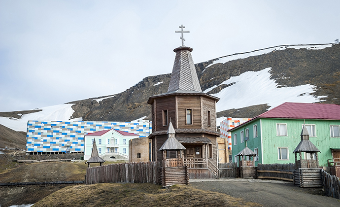
The traditional wooden Orthodox church is a feature of Russian Barentsburg © Ana Flasker, Shutterstock
Barentsburg
Since 2000, Russia has refocused its interest on the Arctic and its strategic value. Subsidies for Trust Arktikugol have increased (though efficiency has not), though sadly the standard of living in Barentsburg still remains lower than in Soviet times, despite considerable donations of clothes, old computers, and so on by the Norwegians. At least the kindergarten and the primary school have been reopened, though in a very improvised way. Russian research is on the increase and plans were underway to establish a new mine at Colesbukta. Russia bullied Norway over laws that normally require detailed documentation on effects on the environment. The new mine was intended to be connected by road to Barentsburg and to replace the current Barentsburg mine, which was limited in its reserves and geologically difficult. Because Barentsburg’s stocks were so depleted and the last mine still in operation had run into recent geological difficulties, a new mine was appealing. However, in 2014 these plans were cancelled and it looks like the new mine will not go ahead.
The Rusanov Memorial Hut on Rusanovodden, Colesbukta, is also worthy of mention. Rusanov’s Svalbard travels, before World War I, were the precursors to Russian settlement and mining in the area. Unfortunately, written information is in Russian only.
Changes in Russia’s presence in Svalbard take time – not least because rival interests are competing for the lucrative funds granted by Moscow. In the meantime, Barentsburg and especially Pyramiden continue to decline, only increasing future renovation costs. With sufficient investment in infrastructure and proper management, Barentsburg could be the site of Svalbard’s most attractive port as an additional source of income, due to its proximity to the open sea and low amount of winter drift ice, making it a suitable place for a service port for fishing and other marine activities in the area. With the new road to Colesbukta, it would also be possible to extend this to Longyearbyen and thus to the island’s main airport. However, such an ambitious project seems rather remote when one looks at the decaying Barentsburg of today.
Barentsburg received a heavy dose of Eastern Bloc architectural realism during its initial construction. The several hundred inhabitants live in a single communal concrete block of flats, built in the Khrushchyovka style, a rather unappealing design that represented an early attempt at industrialised and prefabricated building, with elements (or panels) made at concrete plants and trucked to sites as needed. The structures were originally considered to be temporary housing until the Soviet housing shortage could be alleviated by mature Communism, though in Barentsburg these were given rounded edges to lessen the impact of the bitter winter wind and a large central mosaic depicting the Svalbard landscape populated by heroes of Norse legends. Barentsburg’s most recent visible renovation is a full facelift of the Barentsburg Hotel, hospital, mining administration buildings, many housing buildings and the sport and cultural building. The colourful tiled façades give the place more of a contemporary pre-fab look and feel – a rather out-of-place aesthetic that feels half-IKEA kitchen unit, half-1960s space station. Slowly, the settlement seems to be losing the dilapidated Soviet charm that once lent it an exotic edge.
Hornsund
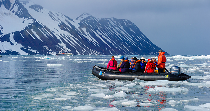
This fjord is one of the most spectacular scenic corners of the west coast. Numerous glaciers terminate into the fjord’s several side arms, while the eastern end of the fjord, Brepollen, is almost completely surrounded by imposing glacier fronts. Between the glaciers, a number of mountains add to the spectacular scenery – first of all the mighty and wild Hornsundtind, which rises directly from the shore to its peak of 1,431m, much higher than any other mountain within 100km. Other remarkable elements of the scenery are the gigantic rock wall of Sophiakammen and the pointed needle of Bautaen.
It is only a few kilometres from here to Hamburgbukta on the east coast and it is a favourite journey of polar bears, the so-called ‘Polar Bear Merry-go-round’; they are also frequent visitors to Hornsund in the summer months. There are many seabird colonies here, as well as remains from the heyday of whaling, walrus hunting and trapping and the important Swedish–Russian meridian expedition around the turn of the 20th century.
The name ‘Hornsund’, together with the low elevation of the glaciers that separate it from Hamburgbukta on the eastern side of the island, has given rise to speculation that it may be derived directly from the English name ‘Horn Sound’.
This indicates that it’s a through-passage rather than just a bay, ie: that the area south of the fjord is connected to the north only by glacier ice, which closed the sound only after the discoverers visited in around 1600, as the ice cover of Svalbard has grown considerably with the climate getting colder over the centuries towards the peak of the ‘little ice age’ in the early 19th century.
Radar measurements of the ice thickness could not solve the riddle satisfactorily as their margin for error was such that the land under the ice could be either just under or above sea level.
Despite its dramatic scenery and the chance of spotting polar bears, Hornsund has been little visited by bigger cruise ships because its entrance is often blocked by ice drifting around southern Spitsbergen, carried by the easterly currents. Only cruise ships with more flexible programmes (and who spot that the area is free of ice when passing by) and a number of longer expedition cruises (especially those circumnavigating Svalbard) include this fjord.
Kapp Linné
Until the end of 2003, the radio station, Kapp Linne, on the southern side of the entrance of Isfjorden, with its huge parabolic antennae, was the telecommunications lifeline for Longyearbyen, connecting the town with the rest of the world. Only here – due to the extreme northern position of the islands and because no mountains obscure the skies to the south – could the dishes of this ground station be directed at the geostationary telecommunication satellite just above the southern horizon as seen from here. In the 1990s, the station was automated and in 2004 it was replaced by the new twin glass-fibre sea cable, which stretches over the sea bottom between mainland Norway and Svalbard, providing a vastly expanded and more stable data-transfer capacity. The station has since been converted into an upmarket lodge run by adventure company Basecamp Explorer.
The several buildings that once housed satellite equipment and accommodation for the staff have been redesigned as a rustic yet chic base for explorations into the surrounding wilderness and adjacent bird sanctuary, onto which the two-dozen rooms now look out.
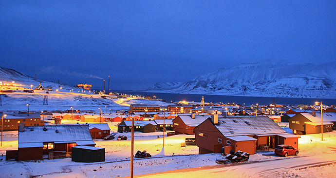
Longyearbyen is Svalbard’s main city © Marcela Cardenas, www.nordnorge.com
Longyearbyen
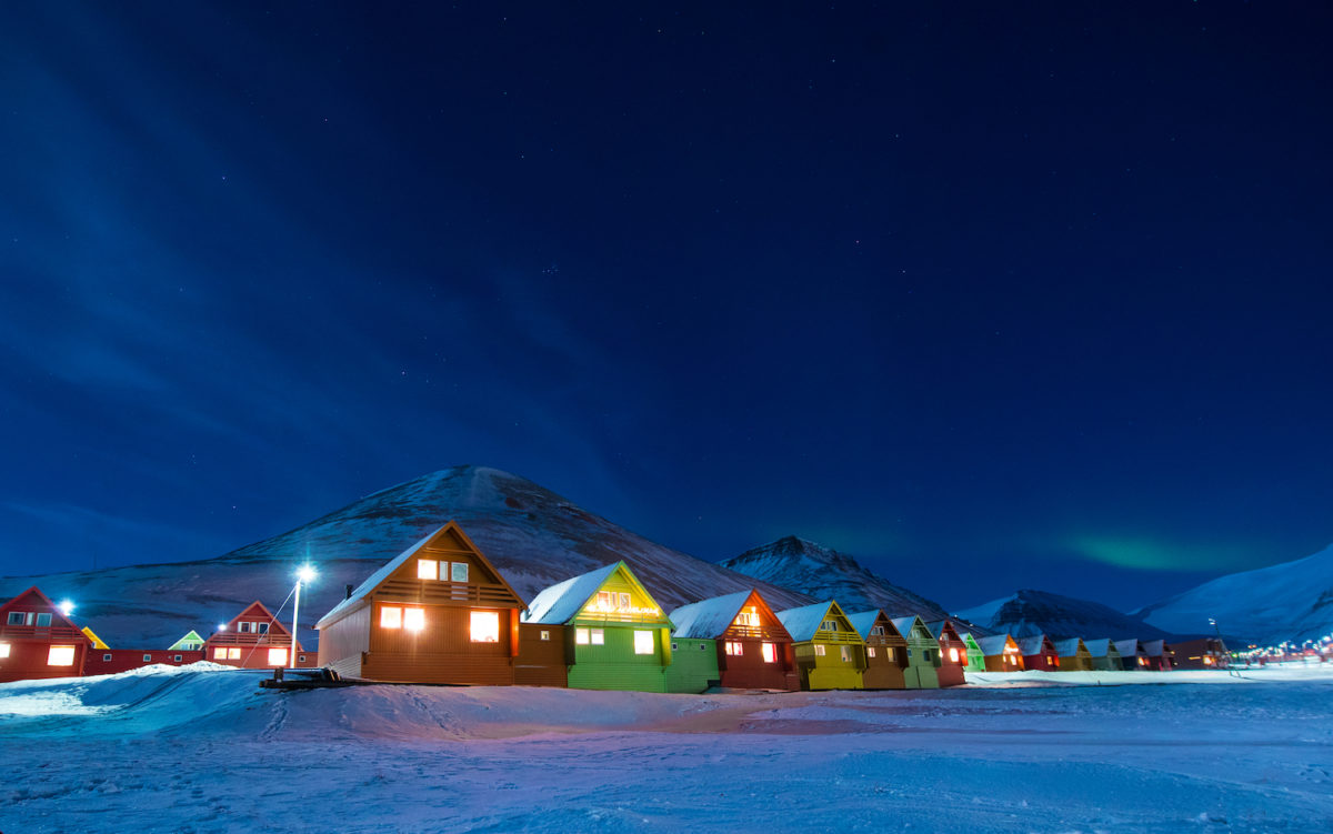
Longyearbyen is Svalbard’s capital and the oldest existing settlement in the archipelago. The aim of turning Longyearbyen into a modern Norwegian town, comparable in many ways with those on the mainland, has for all intents and purposes been met. There are scheduled year-round flights to the mainland, and information and communications technology is as advanced as anywhere else in Scandinavia. Yet its extreme geographical location has required that the town be built on stilts and pylons driven deep into the permafrost. While the impressive range of facilities here might surprise, it should be kept in mind that anything lacking in Longyearbyen is just an 1½ hours’ flight away on the mainland; supplies and assistance from a neighbouring community are readily available if needed. But in the case of Longyearbyen, there are no neighbouring settlements and in winter when ice hinders shipping, the community is still largely dependent on its local resources, which therefore have to be more extensive than in larger mainland settlements, and on the creativity and ingenuity of its residents.
Magdalenefjorden
Magdalenefjorden is the most photographed landmark of Svalbard and its postcard scenery attracts more visitors every year than any other place apart from Longyearbyen – in spite of its relatively remote position in the far northwest. Magdalenefjorden has an alpine feel, with steep sides and a glacier sliding into the sea. On the southern side there is the Gravneset Peninsula as the standard landing site with its beautiful beach and a nicely sheltered anchoring bay called Trinity Haven.
The peninsula shows that this site has attracted men for centuries; in fact, even the discovery expedition of Willem Barents came here in 1596. On the high ground in the middle of the Gravneset, there is an extended graveyard with dozens of difficult-to-recognise whaler graves scattered over the hill and a memorial to the whalers on top; furthermore, there are three areas of remains of old blubber ovens from the 17th-century whaling period down at the beautiful beach. In the 17th century, this was mainly an English whaling base. In the steep mountain slope above Gravneset, little auks breed and on the beach and the lowlands of the peninsula, the chances are you’ll meet arctic terns, skuas, barnacle geese and eider ducks.
Almost all passenger boats anchor in the shelter behind Gravneset, setting people ashore on the beautiful beach for a short walk, and the fjord is also popular for alpine expeditions due to its beauty and hard rocks.
About 20,000 visitors per year inevitably leave their traces, even with excellent environment-conscious behaviour. In fact, Gravneset is about the only place away from the settlements where tourism has left significant traces and often serves as an example of the problems of allowing tourism in Svalbard.
Vegetation on Gravneset, especially in the graveyard area, has suffered severely during more than 100 years of cruise tourism and there has also been considerable damage to the historic remains from the whaling period – mostly due to sheer ignorance, as many of these traces are hardly recognisable to the layman without proper information.
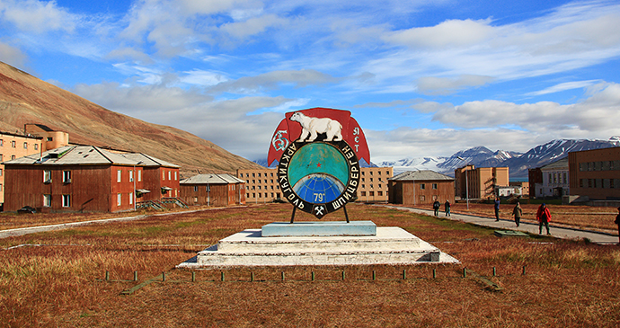
The second Russian mining settlement, Pyramiden, is now an abandoned ghost town © Marcela Cardenas, www.nordnorge.com
Pyramiden
During the 1990s, a modest tourist industry began to develop in Pyramiden, receiving day visitors from Longyearbyen. The hotel was reopened for the summer seasons of 1999 and 2000 on a provisional basis since, by then, the water and heating systems had already been destroyed by winter frost. However, with few long-term prospects and the necessary marketing efforts, the Russian mining company failed to make a go of tourism.
During wintertime, Pyramiden has been completely abandoned since 1998, while in summer, a small team of Trust Arktikugol staff is based here – originally funded by the Russian state to clean up the area, but in reality they simply removed any equipment that could be reused in Barentsburg and collected scrap metal that was then sold by the Arktikugol management to Western buyers. Little maintenance has been done by Trust Arktikugol. Instead, damage has been caused by using explosives for dismantling metal structures as quickly as possible, which at the same time shattered nearby windows. Perhaps even more worrying is the neglect of the protective gravel walls, which guide floodwater around Pyramiden, since the settlement is built within the delta of several streams, which are prone to violent flooding during the period of snowmelt. Today, these walls have been all but washed away and floods have already started to destroy the settlement. Although Russia has rediscovered the value of its strategic outposts in the High Arctic, Arktikugol management has shown little real interest in conserving the original settlement, preferring instead to find a new Pyramiden, inclusive of attractive subsidies.
Renewed activity in the area is certainly possible, not least given the Russian oil industry’s plans to explore and possibly exploit the oil and gas deposits discovered just 10km from Pyramiden across the fjord. Another option would be the albeit ambitious idea of transforming Pyramiden into a base for international research and ecotourism. There have been some half-hearted attempts over the past few years to jumpstart tourism to Pyramiden, which is certainly a step in the right direction.
Related books
For more information, see our guide to Svalbard:
Related articles
Sit back and enjoy this kaleidoscope of colours.
It is, quite simply, magical.
