Nicknamed “America’s Amazon” for its record breaking biodiversity, the state of Alabama has an impressive collection of natural wonders which you can visit by road.
Nature in Alabama
Thanks to the Mobile River basin, Alabama boasts a greater variety of freshwater fish, mussels, snails, turtles, and crawfish species than any other state, and it’s not even a close contest.
Alabama is home to 84 species of crawfish, far outpacing Louisiana’s 32 species and California’s nine, despite California being three times larger than Alabama.
The turtle diversity in Alabama is even more remarkable. The Mobile-Tensaw Delta alone harbours eighteen turtle species, which is more than the Amazon, Nile, Yangtze, Mekong, or any other river system on the planet.
Then there are Alabama’s gorgeous beaches, some leading worldwide development in sustainable tourism.
Finally, Alabama has 22 state parks and two National Heritage Areas in the Black Belt and Muscle Shoals areas.
From shores to ancient canyons, the Yellowhammer State offers a diverse landscape just waiting to be explored.
Interested? Join us as we explore the very best of nature in Alabama and start planning your next road trip.
See also What food is Alabama famous for?
The best natural wonders in Alabama
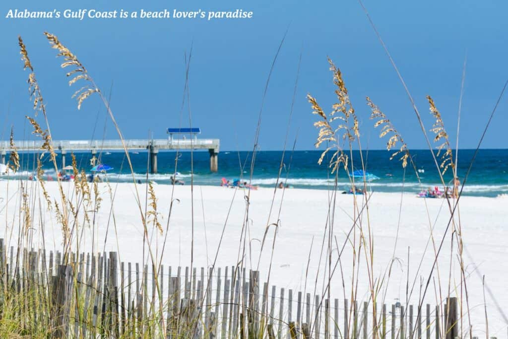
Gulf Coast Beaches
Alabama’s Gulf Coast – a 32-mile stretch of sugar-white sand and emerald waters – is a beach lover’s paradise.
The sand, composed of fine quartz crystals washed down from the Appalachian Mountains, squeaks beneath your feet as you stroll along the shore.
The warm waters of the Gulf of Mexico invite you to swim, kayak, or simply float and soak up the sun.
But coastal Alabama offers more than just sun and sand. Nature enthusiasts will find plenty to explore, from vibrant dunes to serene estuaries teeming with wildlife.
The regional branches and local affiliates of the Nature Conservancy are actively involved in protecting this fragile ecosystem, educating the private landowners and ensuring that future generations can enjoy its beauty.
How to see it by road
The Gulf Coast is easily accessible by car. Take Interstate 10 to Highway 59, leading directly to Gulf Shores and Orange Beach. Once there, you can park and explore the beaches on foot or by bicycle.
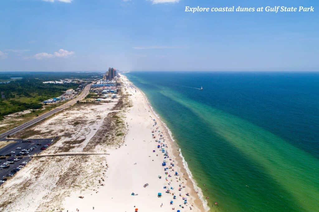
Gulf State Park
A sprawling 6150-acre natural playground, Gulf State Park contains nine distinct ecosystems, each with its own unique charm.
Start by hiking (or biking) the Hugh S. Branyon Backcountry Trail, a 28-mile network and the heart of Gulf State Park, which winds through pine forests, marshes, and wetlands.
Keep an eye out for the endangered Alabama beach mouse, a tiny creature that calls the park’s dunes its natural habitat.
The park is home to 325 species of birds as well as alligators, bobcats and nesting sea turtles. Dubbed the Red Snapper Capital of the World, Orange Beach is the place to go to land a fish, including grouper and amberjack. If you catch a big one, many of the local restaurants will cook it for your dinner.
Beyond the trails, Gulf State Park offers a wealth of activities, from fishing and kayaking on Lake Shelby to mountain biking or birdwatching in the coastal dunes.
Want to put the hiking boots away but still keen to explore the mountains? Our guide to the best mountain railways in the US has you covered.
How to see it by road
Gulf State Park is conveniently located off Highway 59, just a short drive from Gulf Shores and Orange Beach. Once inside the park system, you can explore by car, bike, or on foot.
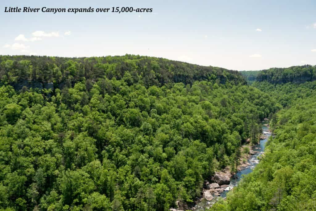
Little River Canyon
Located in northwest Alabama, Little River Canyon is a geological marvel that has been carved into Lookout Mountain over millennia. This 15,000-acre national preserve boasts dramatic sandstone cliffs that plunge into a lush, forested gorge.
Hikers can explore the canyon’s many trails, which lead to scenic overlooks, waterfalls, and hidden grottos perfect for outdoor recreation.
Little River Falls, a 45-foot cascade, is a popular destination, as is the Eberhart Point Overlook, which offers panoramic views of the canyon.
How to see it by road
Little River Canyon is easily accessible via Interstate 59, which runs through the heart of the state. Take Exit 205 for Little River Canyon Parkway, a scenic road that follows the canyon rim, offering breathtaking views at every turn. The parkway is dotted with pull-offs and trailheads, making it easy to stop and explore the canyon’s many wonders.
Wetumpka Impact Crater
Journey to the heart of central Alabama and discover a natural wonder forged by a celestial event. The Wetumpka Impact Crater, a five-mile-wide depression in the earth, is the result of a meteorite that collided with our planet some 85 million years ago.
This geological anomaly is one of the best-preserved craters in the United States, offering a fascinating glimpse into Earth’s tumultuous past.
Though eroded over time, the crater’s rim is still visible as a semicircle of hills surrounding the city of Wetumpka.
A visit to the crater provides a unique opportunity to learn about the forces that have shaped our planet and the natural world.
How to see it by road
The Wetumpka Impact Crater is easily accessible by car. Take Highway 231 to Wetumpka and follow the signs to the crater rim. Several viewing areas offer stunning vistas of the crater’s unique topography.
White Cliffs of Epes
These chalky sentinels formed millions of years ago from the skeletal remains of microscopic sea creatures are a sight to behold. Though access to the cliffs themselves is limited, you can admire their beauty from the Epes Bridge or by driving along the scenic river.
The cliffs are also a popular spot for boaters, who can anchor their vessels in the shadow of these towering formations and soak in the natural beauty of the landscape.
How to see it by road
The White Cliffs of Epes are located in Sumter County, in the western part of the state. To reach them, take Highway 11 south from Livingston. The cliffs are visible from the highway, but for the best views, park at the Epes Bridge and walk along the riverbank.
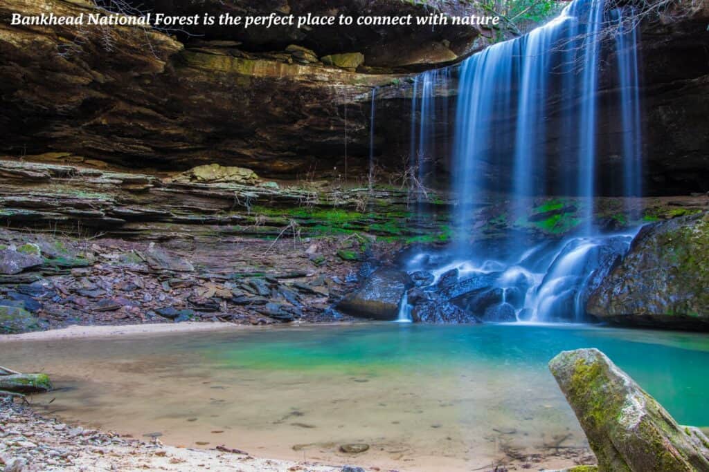
Bankhead National Forest
Nestled in northwest Alabama, this vast expanse of forestland is crisscrossed by rural highways and hiking trails, leading to hidden waterfalls, scenic overlooks, and tranquil streams.
The forest is home to a variety of wildlife, including white-tailed deer, wild turkey, and the occasional bald eagle soaring overhead.
For those seeking a true wilderness experience, the Sipsey Wilderness, a 25,158-acre federally designated area, offers solitude and pristine beauty. Here, you can hike through ancient forests before cooling off in natural pools.
How to see it by road
From Hamilton, take Highway 195 south towards Double Springs. Then, follow the signs for Bankhead National Forest. Once inside, you’ll find several designated recreation areas with parking, picnic facilities, and trailheads.
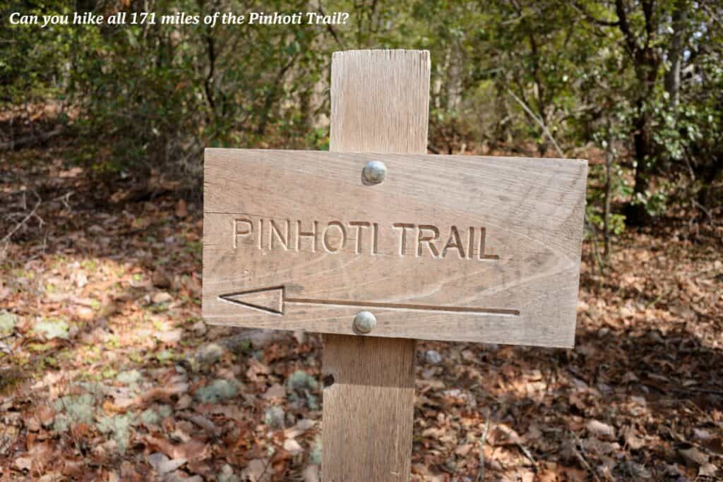
Pinhoti Trail
Embark on an epic journey through the Southern Appalachians on the Pinhoti Trail, a 171-mile footpath that meanders through Alabama’s rugged backcountry.
This challenging trail traverses diverse terrain, from towering peaks to tranquil valleys, offering hikers a glimpse of the state’s wild heart.
Along the way, you’ll encounter gushing waterfalls, cascading streams, and panoramic vistas that will take your breath away. The trail is also home to a variety of plant life, including rare and endangered species.
How to see it by road
The Pinhoti Trail is accessible from several points along its route. Trailheads can be reached by car via various roads, including Highway 78 and Forest Road 600, which provides access to the northern terminus. It’s essential to plan your route carefully and be prepared for the challenges of long-distance hiking.
Walls of Jericho Trail
Northeast Alabama’s rugged beauty is epitomized by the Walls of Jericho Trail, a demanding 6.7-mile roundtrip hike that descends into a natural amphitheatre of towering limestone cliffs and cascading waterfalls.
Though demanding, the reward is a truly unique natural wonder that embodies Alabama’s commitment to the wise use of wildlife and related natural resources.
How to see it by road
The Walls of Jericho Trail is easily accessible from both Alabama and Tennessee. If you’re starting in Alabama, take Highway 72 west from Scottsboro, then turn north onto Highway 79. The trailhead is marked, and a parking area is available for visitors.
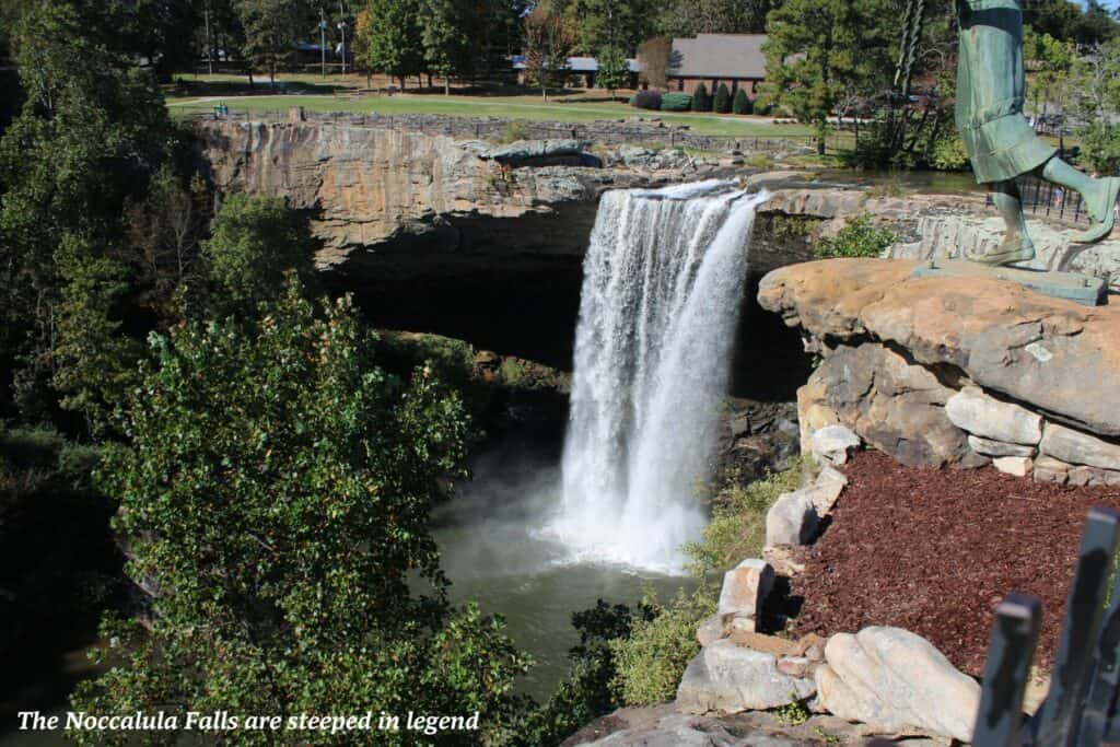
Noccalula Falls
Northeast Alabama boasts another natural wonder in Noccalula Falls, a stunning 90-foot cascade that plunges into a lush gorge. Legend has it that a Cherokee princess, Noccalula, leapt from the falls to escape an arranged marriage, adding a touch of romance to this scenic spot.
How to see it by road
Noccalula Falls Park is located in Gadsden, Alabama, and is easily accessible from Interstate 59. Take Exit 188 and follow the signs to the park. The park is open year-round and offers ample parking. A small admission fee is required, but it’s a small price to pay for the opportunity to experience one of the most beloved natural wonders of Alabama.
Cathedral Caverns
Cathedral Caverns, a subterranean wonderland in north Alabama, beckons explorers to venture beneath the earth’s surface.
This massive cave system is home to colossal stalagmites, towering stalactites, and flowstone formations that resemble frozen waterfalls.
The caverns are also home to a variety of cave-dwelling creatures, including bats and salamanders.
How to see it by road
Cathedral Caverns State Park is located in Kennamer Cove, Alabama, just a short drive from Woodville, and is easily accessible from Interstate 65. Take Exit 267 and follow the signs to the park. The park is open year-round and offers ample parking.
Natural Bridge Park
Natural Bridge Park, located in the northeastern corner of the state, is home to Alabama’s longest natural bridge, a sandstone arch sculpted by erosion over aeons.
Hiking trails wind through the park’s diverse terrain, showcasing a variety of plant life, including wildflowers, mosses and a wide vascular plant colony.
As you wander through the park’s trails, keep an eye out for the different species of birds that call the park home, including warblers, woodpeckers, and hawks.
Need a pick-me-up after a day on the trails? Don’t miss our guide to the Alabama dishes you need to try.
How to see it by road
From Haleyville, take Highway 278 east and follow the signs to the park. The park offers parking and a visitor centre with exhibits on the park’s rich natural history.
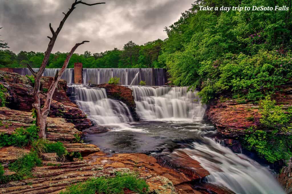
DeSoto Falls & Little River Canyon National Preserve
Northeast Alabama’s Lookout Mountain offers a double dose of natural splendour. DeSoto Falls, a majestic 100-foot cascade, is easily accessible from DeSoto State Park Lodge and is the perfect place for day trips.
Nearby, Little River Canyon National Preserve – carved by one of the longest mountaintop rivers in the U.S. – offers breathtaking vistas and trails revealing hidden waterfalls, swimming holes, and unique geological formations.
How to see it by road
From Fort Payne, take Highway 35 east to DeSoto State Park, where you can park and access the trail to the falls. The Little River Canyon Parkway, a scenic road that follows the canyon rim, is also accessible from Highway 35.
More information
To start planning your next trip, head to Alabama Travel.